Thursday, August 21, 2008
Manigault's Brigade
Marker Text:
July 22, 1864. Manigault’s brigade, Brown’s div., Cheatham’s A.C. (CS) attacked this sector where Martin’s & Lightburn’s brigades were posted astride the Decatur rd. & the Ga. R.R. cut. Manigault’s troops broke the Federal line at the cut, thereby forcing the withdrawal of Lightburn & Martin from this sector of the entrenched line of Logan’s 15th corps.
A counter assault by Lightburn & Martin, together with Manny’s 16th A.C. brigade (brought up from the battlefield area S. of the R.R.), recovered the Federal line & the DeGress battery which Manigault’s men had seized but had not be able to remove
Location: DeKalb Avenue at DeGress Avenue
GPS
Date Visited: July 01, 2008
The attackers, Manigault's brigade; the defenders, Logan's 15th Corps; and the saviors, Lightburn, Martin, and Manny's 16th Corps.
I guess the Confederates did not have enough men to reinforce the sucessful initial attack. Or Hood saw that the rest of the battle was not going well enough to strike a death knell on McPherson's line. I wonder if Hood yet knew that McPherson was dead already?
The 15th Corps Sector
Marker Text
July 20, 1864. Posted on this ridge, astride the Georgia R.R. was the right flank of Hood's old corps, (CS) Gen. B.F. Cheatham commanding. July 22. These troops were withdrawn, before daylight, to the city fortifications. The vacated line was occupied by Logan's corps, (US) which was reversed to face westward.
Gen. Morgan L. Smith's div. centered at the R.R., Lightburn's brigade posted (between DeGress Ave. & Battery Place) west of the Hurt house; Martin's, S. of it - the R.R. cut separating them. The Confederate assault, afternoon July 22d, broke the lines of Lightburn & Martin's brigades at the Decatur Rd. & the railroad cut.
Location: DeKalb Avenue near DeGress Avenue
GPS
Date Visited: July 01, 2008
Here is the defending Federal forces that bore, at least partially, the brunt of the westward attack on July 22, 1864. After moving west into abandoned lines and reversing them, however that happens, the attack would come that afternoon.
It makes me wonder what would have happened if the attack had come sooner, as Hood intended. Then the 15th Corps would not have had time to reverse the line, as I assume, by shifting tempers and redigging trenches etc. Although apparently this sector of the line was swept by the attackers until reinforcements arrived for the Federals. Currently nothing that I could recognize as a railroad cut is left. The MARTA line and railroad on on the otherside of DeKalb Avenue and almost level with the street. Prior to the bridge at Moreland, I wonder what the rail road did. Now the rail road and Marta are kept level up to the bridge. The surrounding ground, however, slopes downward towards the Moreland Avenue road bed and then back up as it continues on towards Decatur.
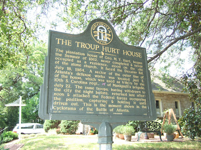
The Troup Hurt House
Marker Text:
The plantation house of George M.T. Hurt, begun the Summer of 1962, never completed and never occupied as a residence, stood on the site of the stone church. It faced the Decatur road.
July 18, 1864. A sector of the outer line of Atlanta’s defense works was located just east of the house, which was used as headquarters by the 10th South Carolina regiment (CS) of Manigault’s Brigade.
July 22. The same troops, having withdrawn to the city the night before, returned late afternoon and attacked the Federal forces occupying the position, capturing and holding it until driven out. This is the moment shown in the Cyclorama of the Battle of Atlanta.
060-97 Georgia Historical Commission erected 1956
Location: DeGress Avenue between DeKalb Avenue and the sharp turn in the road
GPS
Date Visited: July 01, 2008
This marker is in the thick of the entrenched lines fighting on the afternoon July 22, 1864. Again it describes how several brigades were withdrawn one night only to be moved back the next afternoon to attack the lines that they previously occupied.
Another scenario or rational for this feign has come to mind however. Since a full three divisions make a fifteen mile night march to attack the rear of McPherson's lines, I am sure that some troops would be needed to occupy the primary lines in place of those missing. This makes somewhat more sense to me than the other cases.
I do admit that I did look up both "troop" and "troup" out of curiosity and ignorance. Pronounced the same, do they have the same or similar meanings? No, they don't. "Troop" is a group or band assembled for a purpose such as war while "troup" is a proper now associated with people of places.
The other thing that amazes me from this marker is that the plantation house was started in 1862. That is smack-dab in the middle of this Civil War. I was always under the assumption that financial times were hard for everyone, especially in the south and especially to anyone involved in agriculture. Maybe they had to have projects like this in order to keep their slaves busy and therefore preoccupied.
Also, why do so many people in this time period have four names, including their surnames? I mean that is a mouthful...George H.T. Hurt. I am presuming that the "T" stands for Troup. It is called the Troup Hurt house.
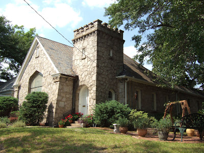
Here is a picture of the stone church mentioned in the marker. It is now a private residence. It was up for sale a couple of years ago and my wife and I got to walk through it. Can't say that I remember much except for the stained glass and thinking that it would be like living in a church.
Thursday, August 7, 2008
Historic Ground -- 1964
Marker Text:
In an area bound by Memorial Drive, Clifton Road, Glenwood Avenue, and Moreland Avenue, was were the major part of the Battle of Atlanta was fought. July 22nd.
In terms of present day landmarks, the battle began at present day Clifton road and Memorial drive where Hardee's right wind (CS) was repulsed in an unexpected clash with Sweeny's 16th Army Corps division (US). This was followed by an assault of Hardee's left wing which crushed the left wing of the 17th Army Corps at Flat Shoals road and Glenwood Avenue and dislodged the right of the 16th Army Corps, forcing them north to a second line at and east of Leggett's Hill - eight hours of battle in which two major Generals, Walker and McPherson, were killed.
044-68 Georgia Historical Marker erected 1956
Location: McPherson Avenue and Monument Avenue
GPS
Date Visited: July 01, 2008
Re-iteration of the ferocity of the battle and the surprise of the attack and the surprise of Sweeny's division. If McPherson hadn't have brought down Sweeny's division, then the full brunt of the attack would have fell directly on the line at Memorial Drive near Leggett's Hill. The 17th Army Corps of the Federals would have had no were to retreat towards. McPherson apparently had pretty good instincts tactically. I believe that he knew Hood well from his time at West Point and possibly the Mexican War. The point that McPherson had been worried about was indeed the area that gave him the greatest test. His armies passed the test ultimately, but he did not. Further research into this moment has determined that Sherman grieved at his loss. Not only did he grieve for his friend, but he also would sorely miss his most trusted "right hand" commander.
Death of McPherson
Marker Text:
The monument in the enclosure was erected by U.S. Army Engineers to mark the site where Major General James B. McPherson was killed during the Battle of Atlanta, July 22, 1864.
McPherson rode south from the Georgia railroad when he heard firing in Sugar Creek valley, where the rear attack by Walker's and Bate's divisions (CS) fell upon Dodge's 16th Army Corps. After pausing to observe this part of the battle, he galloped towards the left of the 17th Army Corps (Flat Shoals road and Glenwood Avenue) on a road through the pines.
At this point he was assailed by skirmishers of Cleburne's division (CS), refusing to surrender he was shot while attempting to escape.
044-45 Georgia Historical Commission erected 1956
Location: McPherson Avenue at Monument Avenue
GPS:
Date visited: July 01, 2008
Well, here it is, the death of McPherson in battle. The second Major General to die in the Battle of Atlanta on July 22, 1864. To tell you the truth, after all of the events and markers leading up to this, it is rather anti-climatic. The monument and the marker are located on a small triangle of land at the intersection of two residential streets. Not a block away north is Interstate 20 and, let me tell you, it is loud, even with the sound barriers up. I believe that this section of the interstate wasn't completed until the late 1950s. So when this marker went up, East Side Avenue may have been a complete road and not cut in two by I-20 like it is today.
Here is the front view of the monument:
The 15th Corps Sector
Marker Text:
July 20, 1864. Posted on this ridge, astride the Georgia Rail Road was the right flank of Hood's old Corps, (CS) General B.F. Cheatham commanding.
July 22. These troops were withdrawn, before daylight, to the city fortifications. The vacated line was occupied by Logan's corps, (US) which was reversed to face westward.
General Morgan L. Smith's division centered at the railroad; Lightburn's brigade posted (between DeGress Avenue and Battery Place) west of the Hurt House; Martin's, S. of it- the Railroad cut separating them.
The Confederate assault, afternoon July 22nd, between the lines of Lightburn's and Martin's brigades at the Decatur Road and the Railroad cut.
060-95 Georgia Historical Commission erected 1956
Located on DeKalb Avenue near DeGress Avenue
GPS
Visited: July 1, 2008
These are the troops that move forward one morning to fill the vacated Confederate defense lines and are subsequently attacked that afternoon by the same Confederates, albeit in the culvert of the railroad line, not towards the entrenchments.
Something still doesn't make much sense about this movement by the Confederates. The only thing that sticks is that possibly the Confederates were trying to get the Federals into new lines that they were not yet comfortable with, a feigning move if you will.