Showing posts with label Dodge. Show all posts

Monday, July 28, 2008

McPherson's Last Ride


Marker Text:

July 22, 1864. When General McPherson heard the firing to the southeast while at luncheon (Whitefoord Avenue and the railroad), he mounted his horse and, sending away most of his staff on various missions, galloped south to this hill.
Here, he observed Dodge's 16th Army Corps in desperate combat with Bate's and Walker's divisions (CS) in Sugar Creek valley. Anxious about the left of the 17th Army Corps (at Glenwood and Flat Shoals Roads), he proceeded on a road through the pines in that direction, accompanied by an orderly and Signal Officer William Sherfy, who reluctantly followed after vainly warning the general that Confederate troops had seized the road.

044-44 Georgia Historical Commission erected 1956
Location: Memorial Drive near East Side Avenue
GPS:
Visited: June 26, 2008

Two days after Gresham's (and Leggett's) division pushed Wheeler toward Leggett's Hill, now the federals must defend the hill from a similar direction. This flanking attack should pin them against the defense line of Atlanta. There must have been a concerted effort to attack eastward from the siege lines, possibly at the railroad cut. But what could they really expect to achieve against an army that is basically surrounding them, cutting off their supplies, may be larger than there force, and does not have to worry about protecting the civilians or their long term welfare? It would be like taking little jabs at the heavy weight fighter all the while waiting for him to hit you with a left hook, a knock out blow. I mean I understand the will to fight for your home and country. I am not sure what was expected of General Hood at this time though. What did Jefferson Davis charge him with, the defeat of General Sherman's invasion?
This area was within a state of flux, changing hands just two days ago. Now from the marker, the left edge of McPherson's line was at Glenwood and Flat Shoals road not a mile from this marker and even closer to the intersection of Interstate 20 and Moreland Avenue, the sight of Leggett's Hill. That is not much of a buffer zone and quite a bulge that he should have expected to be vulnerable. Therefore the reason for shifting of Sweeny's division south to extend the line. Ah..the markers are starting to connect now and tell the story. A puzzle piece begins to show the picture now when connected to several other pieces, even if they are not located adjacent. I can fill in some pieces when there are blank spaces.
Now, the marker lets you know McPherson's fate. It was his last ride. I knew that McPherson died here in the Battle of Atlanta. The fort in East Point is named for him, Fort McPherson. There is a McPherson Avenue in East Atlanta. Now I am assumming that is where he died. I never knew the location of his death, only that it was in the battle for the city. I will quest for this marker as well.
But on my way towards McPherson's avenue, I was delayed by other markers, all along Memorial Drive and inter-related to this fateful day almost 144 years ago.

Monday, July 21, 2008

Noon Under The Trees

Text of the Marker - verbetim, but translated by me
July 22, 1864. General McPherson and staff spent their afternoon in conference at Sherman's headquarters and inspecting Army of the Tennessee lines. Noon found them in an oak grove just South of the railroad where they were joined at luncheon by Logan and Blair, each with his staff. While here, McPherson wrote and dispatched an order to Dodge regarding the destruction of the Georgia railroad. This pleasant respite of discussion and cigars was broken by volley firing to the southeast. The Battle of Atlanta had begun.
All mounted and rode away. McPherson, sending most of his staff on various missions, galloped towards the sound of the guns.

Georgia Historical Commission Marker Number 044-39 Date Erected 1956

Location: DeKalb Avenue at Whitfoord Avenue at Candler-Edgewood MARTA station
GPS:
Date Visited: June 19, 2008


Well, at least this marker falls within the same timeline as the Battle of Atlanta Began Here marker. The sound of guns was from the encounter of Bate's and Walker's divisions with Sweeny's men over on Memorial Drive. This marker is located at the MARTA station on DeKalb Avenue at Oakdale/Whitefoord road (Oakdale on the sorthside of DeKalb avenue and Whitefoord on the south), which is a good mile and a half to two miles away. Now Sweeny's men were spread out in a long line, so some of the fighting may have been closer, but it was a good distance to ride out to as well as keep control over. Hence McPherson's ride towards the gunfire to check his flank position, the one that he had just shored up with Sweeny's division. Leggett's Hill, which is also in the direction of the gunfire, was an artillery placement as well, I believe. Therefore, it would have been of strategic importance.
It still seems like an odd fragment of history to record and to memorialize. The quiet before the storm, perphaps.
From what I understand, the current railroad line mimics the 1864 railroad line. Whitefoord road would be the road that McPherson took to arrive at the scene of the battle. The actual oak grove would have been south of the railroad, therefore on the other side of the rail line from the marker.
To me, this marker is just that, a place marker for a chance meeting that occurs just prior to more important and dangerous events.

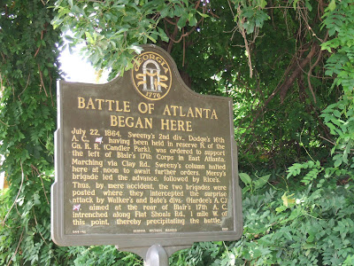
Battle of Atlanta Began Here


Well the title of the marker says it all. Imagine my surprise.


Text of the Marker - Verbatim, but translated by me without all the abbreviations.


July 22, 1864. Sweeny's 2nd division, Dodge's 16th Army Corp (US), having been held in reserve north of the Georgia railroad (Candler Park), was ordered to support the left of Blair's 17th Corps in East Atlanta.


Marching via Clay Road, Sweeny's column halted here at noon to await further orders. Mersy's brigade led the advance, followed by Rice's.


Thus, by mere accident, the two brigades were posted where they intercepted the surprise attack by Walker's and Bate's divisions (Hardee's Army Corps) (CS), aimed at the rear of Blair's 17th Army Corps intrenched (sic) along Flat Shoals road, 1 mile west of this point, thereby precipitating the battle.

Georgia Historic Marker Number 044-46 Erected 1983

Location: Clay Street at Memorial Drive
GPS:
Visited June 19, 2008

Alright before we get to the content of the marker and the significance of it, there are a couple of things that don't make sense to me from the information in this marker.
I presume that Mersy's and Rice's brigades were Union under Sweeny's command, but according to the marker they "led the advance." That wording makes it seem as though they charged the Confederate lines. The reality is probably more along the lines that they led the movement southward down along Clay road. In reality, this movement was spread out along front close to a mile or so long and was not only down Clay road. I will have to measure the distance to the Mersy's Brigade marker further west down Memorial Drive.
The second thing that doesn't make so much sense to me is the location of Blair's 17th Army Corps. The marker says that they were entrenched at Flat Shoals road, 1 mile west of this marker. The only way that Walker and Bate would be able to reach that area is if they were making a swinging loop around. The present day Flat Shoals road does not cross Memorial Drive and is close to a mile and a half away at this point. What were they doing all the way over here? They may have been trying to push up the Memorial Drive road towards Leggett's Hill, which was, from what I have gathered, near the intersection of Flat Shoals road and Moreland avenue in East Atlanta. That makes a little more sense because it would bring in the Confederates push directly into the rear of the Union lines. But it leaves the attacking force's right flank wide open for a counter attack. It would be a risky move. Especially given the fact that once the orders were written and dispatched, adjusting them was a difficult and uncertain task in the days of runners.
Okay, so here my perception changed again. What is defined as The Battle of Atlanta begins here, on the east side of Atlanta away from present day (and, I am sure 1864 day) downtown Atlanta.
Currently this is the in-town suburbs of Atlanta. This section is either in Kirkwood area, or directly south of the Kirkwood area. I wouldn't classify it as ghettos or slums, but it is economically depressed. The housing market here is sketchy. From the mid 1990s or so and on, several houses and areas near here have been renovated and updated in an effort to ride the wave of renovation that has struck several near by areas. But this area, like East Atlanta and Grant Park, are still hit and miss. But that has nothing to do with the battle or the markers.
Here is verification that my initial perception of the southeast attack from Chattanooga to Savannah is entirely incorrect. The encounter at Peachtree Creek, which precedes these events, is not included in the Battle of Atlanta, as per this marker. So now we have the Union, coming from the east and pushing south to cover a flank, being attacked by the Confederates who are marching north to attack to the west. Apparently everyone was in a state of confusion. I certainly am. These events warrant more investigation and information on troop movements prior to July 22, 1864 at noon.
Nevertheless, the two sides clashed here, along Memorial Drive, and the Battle of Atlanta had begun. Now I have used Memorial Drive as long as I can remember. It took me a long while to connect the end that crosses Interstate 285 and continues on towards Stone Mountain (I think that part is Cynthia McKinney Parkway now) to the end that passes the State Capitol. But it is a great thoroughfare. Never did I connect it with the battle though. I see it in different light now. I wonder if all of the people who live next to this marker (and the others as you will see) understand what happened here and how it has affected their black american community. Somehow I doubt that they know. I cannot guess if they would care.